New Zealand Tour Feb-Mar 2026

Sunday, February 3, 2013

Feb 3


Just one more day to the summit, and then the next day, weather permitting, the flight down is planned.

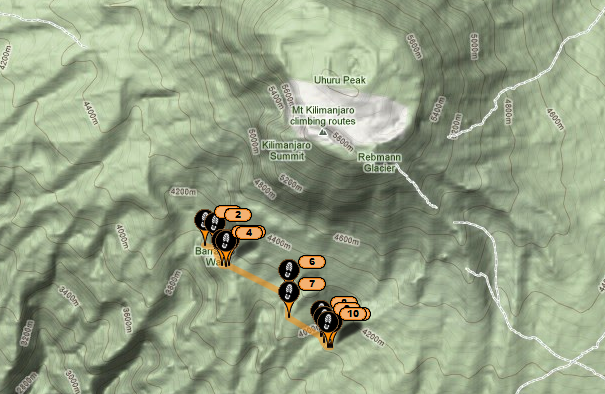
Here are the usual spot and Google Earth captures of Lucille's activity overnight.  I am assuming she is saving whatever battery life remains in her iPhone for the summit or for just before her flight.  Stay tuned for more.

Ted


Saturday, February 2, 2013

Camp 5


We had a great day today. After breakfast we got together in groups and I was lucky enough to be in the group that was being serenaded up the hill. Someone brought his small guitar and was playing while he was walking. There is always a lot if singing and chatter. I thought that I would hate being part of a group so large, but it's actually a lot if fun!!!

Today after the steep hill there was a bit of down then up and down again. Four very slow hours with lots of stopping. Still have lots of people who are not feeling well. Marco and Alan, Mike, Bob and myself are all doing well. We often travel together in a group.

We are all getting excited. Two more days before the summit!!!! Yeah! This is a seven day trek to the summit to give everyone the best chance of making it up. Fingers crossed that we all make it.

This morning would have been a perfect day to launch and fly. What we need are light winds in the right direction....blowing up launch. We are hoping for some wind as we will have to run very hard and fast if there isn't any wind....difficult to do at 19,300 feet or 5900meters!!!!! Our landing zone is at 5000 feet or 1300meters and it is a huge field located 29.7 km away. We would have to try really hard to miss it.

The one thing that has us concerned is the cloud layer......we certainly don't want to be running into each other up there. It usually starts building at around 9am and within 30 minutes we are unable to see the landing zone because if the clouds.

My iPhone battery is getting low and my charging system isn't keeping up so I may not be able to get out another message and if not....keep your fingers crossed on Tuesday night at around 9pm!!!! Watch the SPOTS!!!!!

I will give more details about the charities once we land and I get to visit them....but it's not to late to donate if you wish. None of the money is going to the government....it is going directly to the charities....drilling water wells, building two schools and planting trees.

Bye from everyone here, and thanks for following!!!!
Marco, Alan, Bob, Mike and me....Lucille!!!

Check-in/OK message from WoK Lucille deBeaudrap SPOT Personal Tracker

WoK Lucille deBeaudrap
Latitude:-3.11272
Longitude:37.35452
GPS location Date/Time:02/02/2013 16:12:03 NPT

Message:WoK Pilot Lucille deBeaudrap is OK

Click the link below to see where I am located.
http://fms.ws/B1gP6/3.11272S/37.35452E

If the above link does not work, try this link:
http://maps.google.com/maps?f=q&hl=en&geocode=&q=-3.11272,37.35452&ll=-3.11272,37.35452&ie=UTF8&z=12&om=1


Friday, February 1, 2013

Jambo from Kilimanjaro


The start of a new day. Just four more days till we fly down to th LZ pictured here.


February 1

Jumbo everyone.

Today we headed off after breakfast, around 0830 and headed up. We had the option of heading straight to Barranco camp, or detour to the tower which is what we did then climbed to the top of the tower. Fun. A bit if bouldering. Then we kept going up to arrow glacier. A long day but we are all feeling good!

Mike is just as crazy as ever...Marco and Alan are doing well, and so is Bob. We are taking lots of photos of the group....so big!!!

My young porters are very nice and working hard. We have also met many guides...all very nice. The food is not spectacular....but it is filling us up.

Mike told Marco that they were going to have a cricket match on the summit. Marco didn't understand so Mike said yes, they draw a big circle, and take the little crickets and put them on the outside and the race is to see who makes it to the middle first!!!!! Marco believed him. Several hours later Marco asked me what mike had said!!!!

Today, although we are above the tree line we did see some beautiful flowers, some green shrubs and a waterfall. So much to see here. There are many different routes up this volcano. I thought that it would be all dry and dusty but actually we have seen a lot of lush areas. We have had rain every day...yesterday only at night.

There are some big clouds building and Marco says if the rain comes then tonight we will go kayaking!!!

Mad Mike Kung had a few flights yesterday and another one today. There is a reason his name starts with Mad!!!

And finally, a shout out to the grade three class at Trochu Valley School and the grade six class at the Good Shepard in Peace River. Both these classrooms were special contributors to my fundraising and I am thinking of you every day.

Lucille

Check-in/OK message from WoK Lucille deBeaudrap SPOT Personal Tracker

WoK Lucille deBeaudrap
Latitude:-3.09502
Longitude:37.33075
GPS location Date/Time:02/01/2013 21:49:09 NPT

Message:WoK Pilot Lucille deBeaudrap is OK

Click the link below to see where I am located.
http://fms.ws/B1Dwb/3.09502S/37.33075E

If the above link does not work, try this link:
http://maps.google.com/maps?f=q&hl=en&geocode=&q=-3.09502,37.33075&ll=-3.09502,37.33075&ie=UTF8&z=12&om=1


Thursday, January 31, 2013

Check-in/OK message from WoK Lucille deBeaudrap SPOT Personal Tracker

WoK Lucille deBeaudrap
Latitude:-3.04262
Longitude:37.29983
GPS location Date/Time:01/31/2013 15:13:40 NPT

Message:WoK Pilot Lucille deBeaudrap is OK

Click the link below to see where I am located.
http://fms.ws/B0X56/3.04262S/37.29983E

If the above link does not work, try this link:
http://maps.google.com/maps?f=q&hl=en&geocode=&q=-3.04262,37.29983&ll=-3.04262,37.29983&ie=UTF8&z=12&om=1

The group has advanced to nearly 4200m at the Moir camp.


Here is the full Itinerary if they stay on Schedule.

January 29 – Machame Gate, 1790m. Walk to Machame Camp, 3010m

January 30 – Walk to New Shira Camp, 3845m. Those of us feeling fit will walk around the Shira Plateau and summit the Shira Cathedral in the afternoon and then walk back to the New Shira in time for dinner.

January 31 – Walk along the edge of the Shira Plateau and setup at Moir Camp, 4175m.

February 1 – Walk South East for Lava Tower 4640m and stop here for lunch. Those people feeling fit and not too affected by the altitude will then climb another vertical 190m to Arrow Glacier, 4830m (and just higher than Mt Blanc!). Here we are at the foot of the Western Breach Route to the summit. We will then head back down to Barranco Camp, 3960m, joining the other lazy buggers who went straight downhill from Lava Tower. This walk takes us through what our team christened the Garden of Eden (Original huh?) and is one of the coolest days on the walk! Spectacular!

February 2 – Begin to turn East and climb the steep gorge out of Barranco and cross over into the Karanga Valley making camp at Karanga, 4035m.

February 3 – The climb begins to start heading North east and skyward, passing through Barrafu Camp at 4640m and setting up at high camp above Barrafu at around 4900m. 1 more day to go!

February 4 – Summit Day! Monday 4th of February 2013 is the day that the biggest group ever to summit Kilimanjaro begins to head North West to Stella Point, 5730m and continues onto Uhuru, 5895m for the biggest group photo (maybe ever??) on any one of the 7 summits! From Uhuru, we will walk down the crater to find a got dinner and tents ready for sleeping at Crater Camp, also at 5730m. Those feeling fit will explore the many glaciers at Kilimanjaro and also walk to the Reusch Crater, Kilimanjaro’s still active volcano shute.

February 5 – Something about getting off the mountain in a hurry.. James Bond Style!

Ted